The coastal climate of Geelong, with its high water table near Corio Bay and the volcanic basalts of the Bellarine Peninsula, creates a challenging environment for subsurface investigation. Traditional boreholes alone often miss lateral variations in these layered soils. Electrical resistivity and VES surveys provide continuous, non-invasive imaging of the ground, mapping changes in saturation, clay content, and bedrock depth across large areas before a single drill rig mobilises. This approach is especially valuable for infrastructure projects along the Barwon River floodplain, where saline intrusion and variable alluvium demand a broader spatial understanding than point tests can offer. Complementing resistivity data with georadar (GPR) allows cross-validation of shallow anomalies, while permeability field tests help quantify flow rates in the identified conductive zones.
Resistivity surveys in Geelong’s coastal basalts can detect saline intrusion and clay lenses that boreholes alone routinely miss, reducing foundation risk.
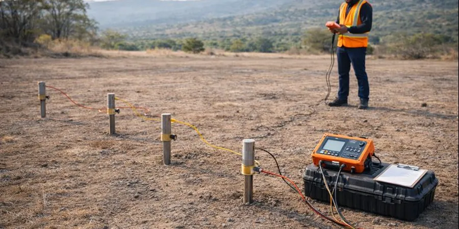
Scope of work in Geelong
- Depth to bedrock or competent volcanic rock, critical for foundation design in areas like Waurn Ponds or Grovedale.
- Groundwater salinity and saturation patterns, especially near the coast where tidal influences affect resistivity values.
- Clay lenses and paleochannels that can cause differential settlement if left undetected.
Demonstration video
Typical technical challenges in Geelong
Geelong’s rapid urban expansion over the last two decades has pushed development onto marginal land: former quarries, reclaimed wetlands, and the steep slopes of the You Yangs foothills. Without proper geophysical imaging, these areas present a real risk of differential settlement, slope instability, or unexpected groundwater ingress during excavation. Electrical resistivity surveys provide a cost-effective early screening tool that identifies problem zones before detailed invasive testing begins, saving both time and remediation costs on projects that might otherwise face costly redesigns mid-construction.
Our services
We offer three specialised resistivity and VES services tailored to Geelong’s diverse geological settings.
2D Electrical Resistivity Tomography (ERT)
Continuous imaging along survey lines up to 200 m, ideal for mapping bedrock depth, groundwater salinity, and buried channels across large development sites in Geelong’s coastal and volcanic terrains.
Vertical Electrical Sounding (VES)
Point-based depth soundings using Schlumberger or Wenner arrays to determine layer resistivity and thickness. Best suited for deep foundation investigations and groundwater resource assessments.
Time-Lapse Resistivity Monitoring
Repeated surveys over weeks or months to track changes in moisture content, leachate migration, or dewatering effects. Commonly applied at landfill sites and construction dewatering projects around Geelong.
Frequently asked questions
How deep can electrical resistivity surveys reach in Geelong’s soils?
In typical Geelong conditions — basaltic clay, alluvial sand, and weathered siltstone — VES soundings can reach up to 100 m depth with large electrode spacings. 2D profiles are typically limited to 50 m, but provide continuous lateral coverage that is more useful for foundation layout planning.
What is the difference between VES and 2D resistivity imaging?
VES measures resistivity at a single point as a function of depth, giving a 1D layered model. 2D imaging uses multiple electrodes along a line to produce a cross-section that reveals lateral changes in soil and rock. For Geelong sites with variable fill or basalt flows, the 2D method is usually preferred.
Can resistivity surveys detect groundwater salinity near Corio Bay?
Yes. Saline groundwater has very low resistivity (typically below 3 ohm-m), which contrasts sharply with fresh water (10–100 ohm-m) or dry basalt (>500 ohm-m). Resistivity profiles are highly effective at mapping the extent of saline intrusion in coastal Geelong developments.
How much does an electrical resistivity survey in Geelong cost?
For a standard 2D profile of 100–200 m in the Geelong region, you can expect to pay between AU$880 and AU$1,700, depending on site access, line length, and the number of profiles. Larger subdivisions or multi-line surveys typically reduce the per-line cost.