Geelong sits on a complex Quaternary geology of basalt flows, alluvial sands, and marine silts, making subsurface assessment for infrastructure works particularly challenging. A GPR (Ground Penetrating Radar) survey in Geelong is often the first non-intrusive step recommended under AS 1726 for site classification, especially when the aim is to locate buried services before excavation. The method uses high-frequency electromagnetic pulses to detect contrasts in dielectric permittivity, giving a continuous profile of the shallow subsurface. For projects along Corio Bay or the Barwon River floodplain, we routinely pair GPR with resistivity surveys to differentiate between saturated sands and clay layers where radar signal attenuation is high.
GPR is the only non-destructive method that delivers continuous subsurface images at walking pace, ideal for Geelong's mixed basalt and alluvial soils.
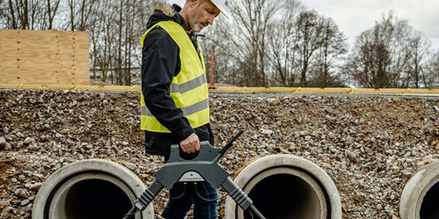
Scope of work in Geelong
Typical technical challenges in Geelong
The Newer Volcanics basalt that underlies much of Geelong causes strong radar wave scattering and signal attenuation below 1 m, which can mask deeper features like pipes or old footings. Similarly, saturated estuarine clays near the Barwon River mouth produce high electrical conductivity that absorbs the radar pulse within 0.5 m. Misinterpreting these conditions as 'no anomaly' is a common error that leads to unexpected utility strikes or foundation surprises. Our field team compensates by switching to lower-frequency antennas and applying time-varying gain during acquisition, ensuring that the risk of false negatives is minimised in these challenging geologies.
Our services
Our GPR survey services in Geelong are modular and can be tailored to site constraints and client budget. Each option includes full data processing and a written interpretation report.
Utility and Service Location
Pre-excavation scanning to mark gas, water, power, and telecom lines using 400 MHz and 800 MHz antennas. Delivered as colour-coded plans overlain on the site layout.
Concrete and Slab Scanning
High-resolution 1.6 GHz surveys to map rebar, post-tension cables, and voids in concrete slabs. Common before coring or cutting in Geelong's commercial buildings.
Geological and Archaeological Mapping
200 MHz surveys to delineate basalt bedrock depth, paleochannels, and buried cultural features. Used for environmental site assessments and heritage compliance.
Frequently asked questions
How deep can GPR penetrate in Geelong soils?
In dry sands and gravels — up to 5 m with a 200 MHz antenna. In clay-rich soils typical of the Barwon River floodplain — rarely more than 1.5 m. Saturated saline clays reduce penetration to 0.5 m or less.
What is the typical cost of a GPR survey in Geelong?
A standard utility survey for a block of land runs between AU$13.040 and AU$2.120 depending on area, antenna configuration, and reporting detail. Concrete scanning is quoted per square metre.
Can GPR detect basalt boulders in the subsurface?
Yes, provided the boulder has a sharp dielectric contrast with the surrounding soil. We have successfully mapped basalt floaters in the Belmont and Highton suburbs, where they often sit just below the topsoil.
Do you need to clear the site before the survey?
We need clear access to the ground surface. Heavy vegetation, metal debris, or standing water degrades signal quality. A quick site walk with the client beforehand ensures we pick the right antenna and grid layout.