Too many builders in Geelong treat a steep block the same as a flat one, and that's a mistake we see year after year. They assume surface water management is enough, but the real threat lies in the subsurface soil movement that can turn a rainy season into a landslide event. A proper debris flow analysis is not just a box to tick — it's the difference between a stable foundation and a call from the council about a slipped retaining wall. We've been called in after the fact more times than we'd like, and the cost of remediation always dwarfs the upfront study. Before you break ground on that sloping site near the Barwon River, pair this analysis with a geotechnical drainage study to map how water actually moves through the colluvium layers typical of this region.
A one-in-50-year storm in the Otway foothills can mobilise debris flows that travel over two kilometres from the source zone with surprising force.
Scope of work in Geelong
Typical technical challenges in Geelong
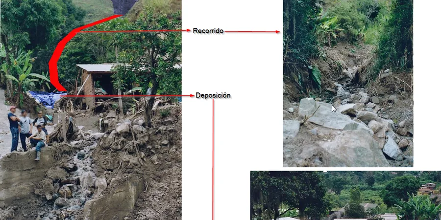
A residential development we assessed near the You Yangs had a 12-metre slope that looked stable enough during a dry summer. Come July, a 72-hour rain event turned that slope into a mud torrent that smashed through a rear fence and deposited over fifty cubic metres of debris against a patio door. The owners had assumed a simple drainage trench would handle it — they were wrong. The debris flow analysis we did afterwards showed the failure plane ran three metres deeper than anyone expected, and the whole slope was sitting on a slickensided clay seam left over from an ancient landslide. That kind of hidden geometry is exactly what a proper study catches before you sign off on the slab.
Our services
We offer two core approaches for debris flow analysis in Geelong, matched to the complexity of your site and the level of risk involved.
Desk-based Hazard Screening
A preliminary review using LiDAR-derived topography, regional geology maps, and historical rainfall data. We produce a susceptibility index for your property that flags whether a full field study is warranted. Ideal for early due diligence or small subdivisions.
Full Quantitative Debris Flow Model
Field mapping of source zones, soil sampling for index properties, and numerical modelling with FLO-2D or RAMMS. You receive a hazard map with runout zones, impact pressures, and design recommendations for mitigation structures like deflection berms or catchment basins.
Frequently asked questions
What is the difference between a debris flow and a mudslide?
A debris flow is a fast-moving mixture of soil, rock, and water that travels down a steep channel, often reaching speeds over five metres per second. A mudslide, on the other hand, is a slower, more cohesive movement of fine-grained material along a defined shear surface. Debris flows are more destructive because they carry boulder-sized clasts and can travel much farther from the source.
How much does a debris flow analysis cost for a residential property in Geelong?
For a standard residential lot in Geelong with moderate slope, expect to pay between AU$1,960 and AU$6,870 depending on site access, the complexity of the drainage network, and whether you need a full numerical model or just a screening study. Steep sites in the Otway foothills tend to sit at the higher end.
Do I need a debris flow analysis if my block is outside the official landslide zone?
Yes, absolutely. The official hazard maps from the City of Greater Geelong only cover broad regional susceptibility, not site-specific conditions. We have found active debris flow paths on properties well outside the mapped zones, particularly where old drainage lines have been filled or diverted. The only way to be sure is a site visit and a field-based assessment.